Historic Maps
-
 Price range: $30.00 through $80.00
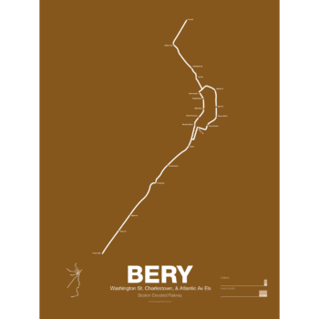
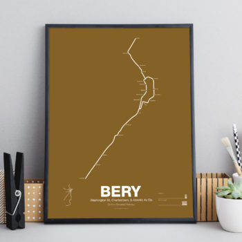
What is today the Orange Line was part of the original Boston Elevated Railway subway and elevated network. Today the only section remaining is the Washington St Tunnel from Haymarket to Chinatown. Originally there were two lines through downtown: the Main Line and the Atlantic Ave El. The Main Line served elevated branches from Charlestown and along Washington St to Dudley Sq. in the South End. The Atlantic Ave El ran from Castle Sq. in the South End to North Station along Atlantic Ave to serve the maritime industries along the waterfront.
As the city grew so did the elevated lines, being extended to Forest Hills and Everett (a further extension to Malden was halted until the 1970s). As the maritime industry faded and ridership dropped the Atlantic Ave El was demolished and sold for scrap during World War II.
While the El served the city well it was not popular as it was loud, dark, and dirty. Plans were laid as early as 1945 to remove the El and rebuild as a subway.
In the 1970s the city canceled ambitious plans to run highways through and around the city and monies were transferred to subway construction. The northern section was rebuilt first, removing the elevated tracks through Charlestown and moving them west along a new subway to Malden in 1975.
The southern section was rebuilt along the route for the canceled I-95 expressway through Jamaica Plain to Forest Hills in 1987. While the new Orange Line was modern and fast the new route bypassed the existing community of Roxbury which relied heavily on mass transit. Service along the old route was replaced by the Silver Line bus in 2002.
Printed on Satin finish 80# cover stock – 220 GSM. Made in the USA! Standard production time is 5 Days. Please add more time for shipping.
Select options This product has multiple variants. The options may be chosen on the product page -
 Price range: $30.00 through $80.00
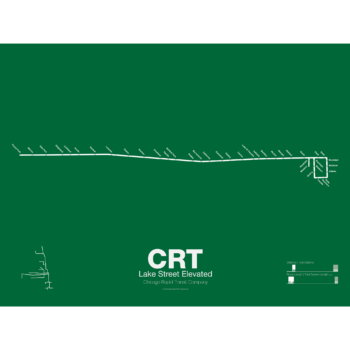
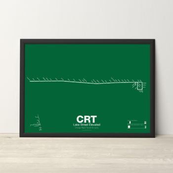
The Lake Street Elevated was Chicago’s second elevated line opening in 1893. In 1993 the CTA reorganized routes and color coded the new Lake St-South Side Lines as the Green Line.
Printed on Satin finish 80# cover stock – 220 GSM. Made in the USA! Standard production time is 5 Days. Please add more time for shipping.
Select options This product has multiple variants. The options may be chosen on the product page -
 Price range: $30.00 through $80.00
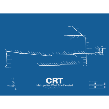
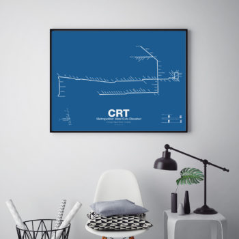
In 1895 the Metropolitan West Side Elevated Railroad began with service from Canal St to Logan Sq. Soon branches were added to Garfield Park, Humboldt Park, and Douglas Park. The Met, as it was known, has seen the most dramatic changes of all the Chicago “L” lines: the Humboldt Park and Logan Sq branches were removed when service was rerouted through the new Milwaukee-Dearborn Subway in 1951 and subsequently extended along the Kennedy Expressway to Jefferson Park in 1970 and then to O’Hare Airport in 1984. The Garfield Park branch was completely rebuilt along the median of Interstate 290 in 1958. In 2008 the Douglas Branch was rerouted along the Paulina Connector (a left over section of track from the old Logan Sq branch) to connect to the Loop and rebranded as the Pink Line.
Printed on Satin finish 80# cover stock – 220 GSM. Made in the USA! Standard production time is 5 Days. Please add more time for shipping.
Select options This product has multiple variants. The options may be chosen on the product page -
 Price range: $30.00 through $80.00
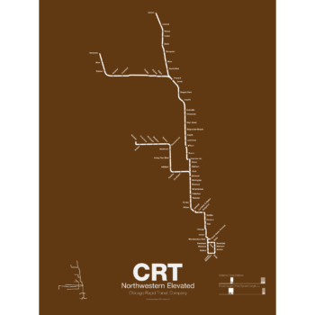
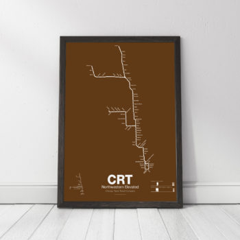
The Northwestern Elevated opened in 1907 and ran from a terminal on North Water St before it connected to Loop. The Main Line ran north to Evanston and a branch was built to Kimball. When the Northwestern was consolidated into the Chicago Rapid Transit Commission a second branch to Skokie was connected which once allowed interurban trains to run from the Loop to Milwaukee. The Northwestern division was split into the Brown, Purple, Yellow, and Red Lines.
Printed on Satin finish 80# cover stock – 220 GSM. Made in the USA! Standard production time is 5 Days. Please add more time for shipping.
Select options This product has multiple variants. The options may be chosen on the product page -
 Price range: $30.00 through $80.00
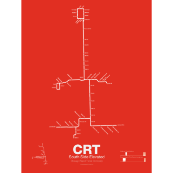
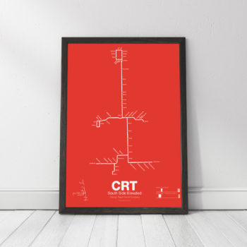
The South Side elevated opened in 1892 to serve the Columbian Exposition in 1893 and led to a building boom on the south side of Chicago. A number of branches were added to the line, to Englewood, Normal Park, Kenwood, and the Stock Yards. Today only the Englewood and Jackson Park branches remain while a number of stations have been closed due to low ridership.
Printed on Satin finish 80# cover stock – 220 GSM. Made in the USA! Standard production time is 5 Days. Please add more time for shipping.
Select options This product has multiple variants. The options may be chosen on the product page -
 Price range: $25.00 through $80.00
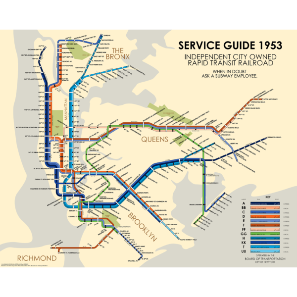
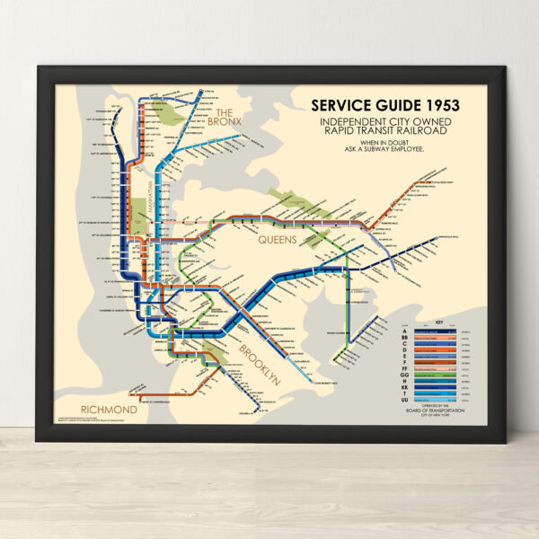
A fictitious service guide of the IND division, New York Subway, had the 1939 Second System plans been built after World War 2. This service diagram is based off of the original Board of Transportation map of 1937 showing the new IND 8th Ave Lines, and the modern update done by Chris Neuherz.
The map is printed at 16″x20″ on Satin finish 80# cover stock – 220 GSM. Made in the USA! Standard production time is 5 Days. Please add more time for shipping.
Select options This product has multiple variants. The options may be chosen on the product page -
 Price range: $25.00 through $80.00
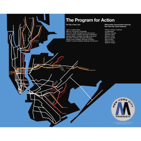
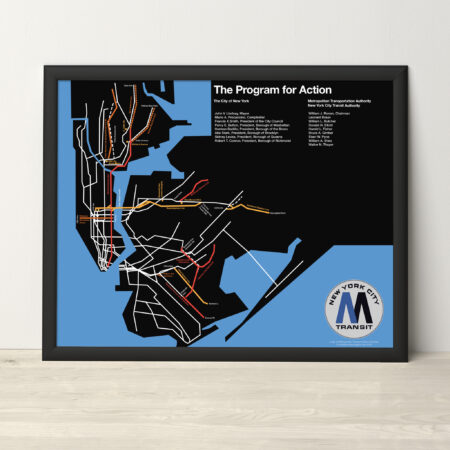
The Metropolitan Transportation Authority of New York was founded in 1968 with the mission of unifying all transit facilities under one roof. To reverse decades of under-investment of mass transit, the MTA released their ambitious Program for Action, a multiphase rehabilitation and expansion of the subways and commuter rail. At the core of the program was the 63rd St Tunnel and 2nd Ave Subway. Elevated lines in the Bronx, Queens, and Brooklyn would be replaced by subways, and existing lines would be extended deeper into the outer boroughs. The LIRR would be extended to Midtown East and Lower Manhattan, while electrification would be expanded on Long Island and the Hudson Valley.
The ambitions of the new agency immediately ran into the harsh reality of decades of disinvestment. The costs of simply fixing what existed proved vastly more expensive than originally thought. The City of New York had been over spending on services at the same time as the tax base dwindled. Within 6 years, most of these plans were quietly shelved. Work on the 2nd Ave Subway was halted (only to be restarted in 2007). Only the 63rd St Tunnel, which had advanced too far to cancel, and the Archer Ave Subway in Jamaica, which was being built with Federal funds, limped along. Both would only open in the late 1980s.
This print is a recreation of a promotion brochure from 1969. A more in depth history, with additional maps, can be found on my blog.
The map is printed at 16″x20″ on Satin finish 80# cover stock – 220 GSM. Made in the USA! Framed prints at the same size are also available. Standard production time is 5 Days. Please add more time for framing and shipping.
Select options This product has multiple variants. The options may be chosen on the product page