Printed on Satin finish 80# cover stock – 220 GSM. Made in the USA! Standard production time is 5 days. Allow more time for shipping.
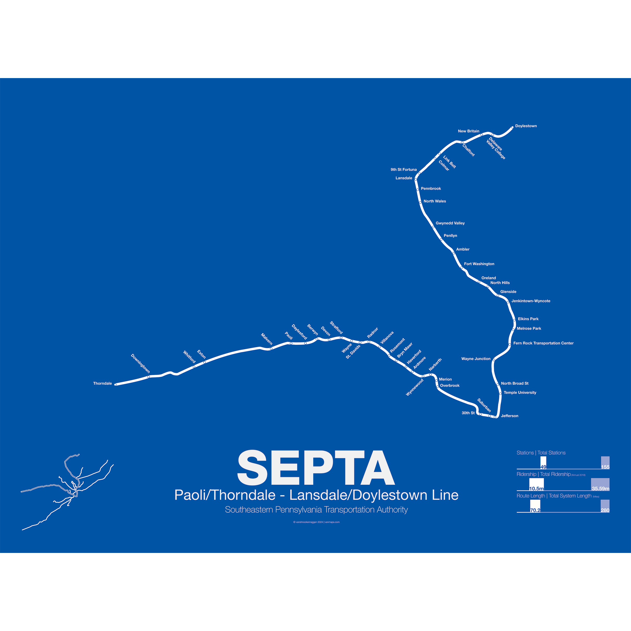
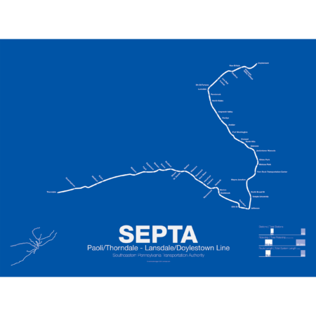
SEPTA Regional Rail R5: Paoli/Thorndale – Lansdale/Doylestown Line
$30.00 – $80.00
Additional information
| Weight | 1 lbs |
|---|---|
| Dimensions | 3 × 3 × 24 in |
| Size | Framed 18"x24", 18" x 24", 24" x 36 |
Related products
-
 $30.00 – $80.00
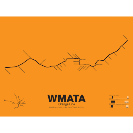
The Orange Line was the third leg of the Washington Metro to open, though service began running in 1978 as a one way service along the existing Blue Line from New Carrollton to National Airport. It wasn’t until a year later in 1979 that the Orange Line was extended out to Ballston when it began running in both directions. In 1986 the line was extended out to Vienna. Plans at the time to reroute the line through the fast developing Tysons Corner were eventually dropped to prevent a five year delay in construction.
These plans were resurrected with the Silver Line being built through Tysons Corner on its way to Dulles Airport. The Orange Line through Virginia runs along the median of Interstate 66 from Vienna to Falls Church. Originally the line was to run along the median of I-66 through Arlington but city planners rerouted it through downtown Arlington which helped stimulate dense residential development in central Arlington.
From Roslyn to Stadium-Armory the Orange and Blue lines share their downtown subway tunnel and split after ascending to the surface on a bridge over the Anacostia River. From here the Orange Line runs alongside the CSX/Amtrak ROW to New Carrollton.
Printed on Satin finish 80# cover stock – 220 GSM. Made in the USA! Standard production time is 5 Days. Please add more time for shipping.
Select options This product has multiple variants. The options may be chosen on the product page -
 $30.00 – $80.00
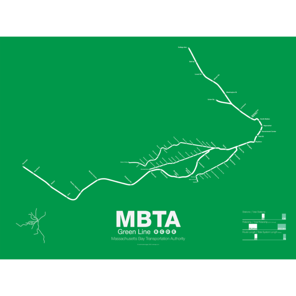
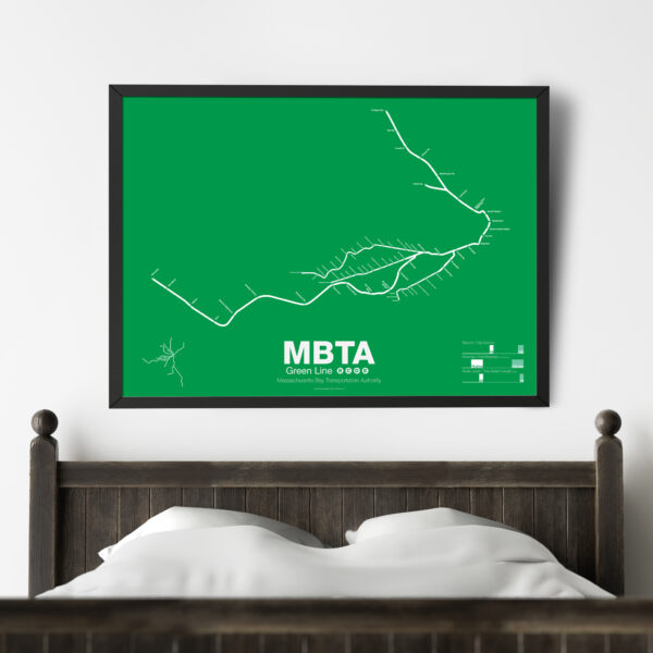
The Green Line is part of the oldest subway in the United States. The short section between Boylston St and Park St opened in 1897 as a way to divert heavy trolley traffic which came downtown from Allston, Brighton, Brookline, Jamaica Plane, Roxbury, and Dorchester. It was quickly expanded to North Station to serve trolley traffic from the northern suburbs.
As commuting patterns changed due in part to the success of the subway the Green Line was extended west to Kenmore Sq and in the 1940s southwest along Huntington Ave. As more and more commuters chose to travel in private automobiles ridership on the trolleys dropped. In 1959 the Riverside branch was opened along a former commuter rail line through Newton. A rebranding of the MBTA system in 1967 renamed the branches that were left as the A, B, C, D, and E branches. The A branch to Watertown Sq. only lasted two more years before finally being axed in 1969.
Boston College B Branch trains run along Commonwealth Ave to Government Center; Cleveland Cirlce C Branch trains run along Beacon St to North Station; Riverside D Branch trains run along the Riverside line through Newton to Government Center; Heath St E Branch trains run along Huntington Ave to Lechemere. Construction has begun on a long planned extension northwest through Somerville which will bring the E branch to Union Sq and the D to College Ave-Tufts University.
Printed on Satin finish 80# cover stock – 220 GSM. Made in the USA! Standard production time is 5 Days. Please add more time for shipping.
Select options This product has multiple variants. The options may be chosen on the product page -
 $30.00 – $80.00
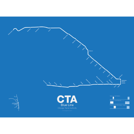
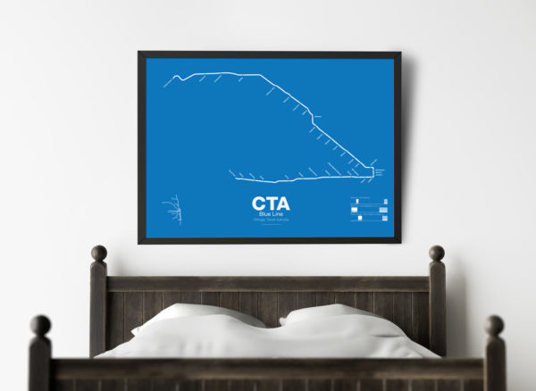
What today is the Blue Line started in 1895 as the Metropolitan West Side Elevated Railroad with service from Canal St to Logan Sq. Soon branches were added to Garfield Park, Humboldt Park, and Douglas Park. The Met, as it was known, has seen the most dramatic changes of all the Chicago “L” lines: the Humboldt Park and Logan Sq branches were removed when service was rerouted through the new Milwaukee-Dearborn Subway in 1951 and subsequently extended along the Kennedy Expressway to Jefferson Park in 1970 and then to O’Hare Airport in 1984. The Garfield Park branch was completely rebuilt along the median of Interstate 290 in 1958. In 2008 the Douglas Branch was rerouted along the Paulina Connector (a left over section of track from the old Logan Sq branch) to connect to the Loop and rebranded as the Pink Line.
The modern sections of the Blue Line were the first examples of rapid transit running along a high median in the US. The Blue Line, along with the Red Line, are the only two services of the CTA which run 24 hours a day.
Printed on Satin finish 80# cover stock – 220 GSM. Made in the USA! Standard production time is 5 Days. Please add more time for shipping.
Select options This product has multiple variants. The options may be chosen on the product page -
 $30.00 – $80.00
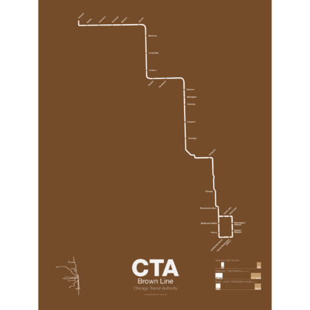
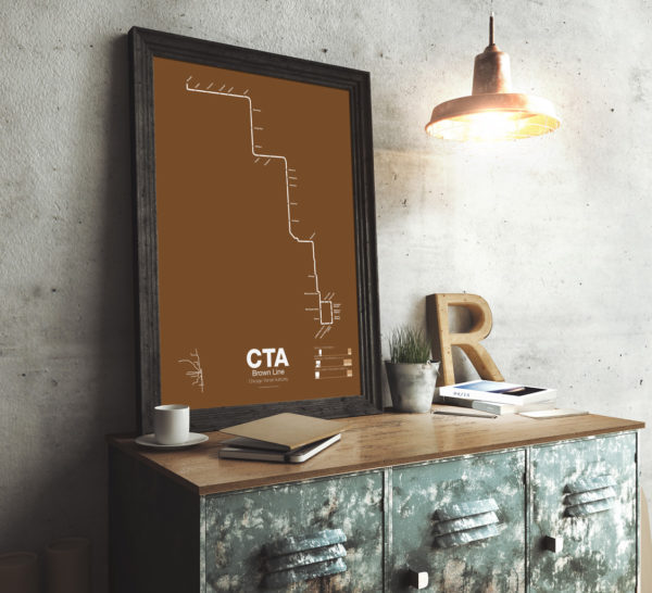
The Brown Line began as the Northwestern Elevated in 1907 and runs from its terminal at Kimball to the Loop and back, making a zig-zag through the northwest section of the city. At the terminal at Kimball trains run at street level with third-rail power which is rare for transit in the US and extremely dangerous for pedestrians. Brown Line trains run local with Red Line trains from Belmont to Fullerton. Recently the stations of the Brown Line were expanded and upgraded to be ADA compliant to deal with rapid population growth on the north side.
Printed on Satin finish 80# cover stock – 220 GSM. Made in the USA! Standard production time is 5 Days. Please add more time for shipping.
Select options This product has multiple variants. The options may be chosen on the product page