MTA Metro North Railroad
-
 Price range: $30.00 through $80.00
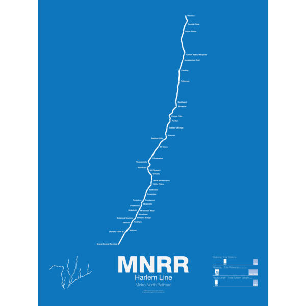
The Metro North Harlem Line runs from Grand Central Terminal in Manhattan to Wassic in Dutchess County, running through the posh suburbs in Westchester. The railroad began as a horse drawn streetcar line from lower Manhattan to the distant suburb (at the time) of Harlem in 1831. The line quickly grew with ambitions to reach Albany and beyond but only got to Chatham, NY in 1852 where riders could transfer to other trains to Boston, Albany, and to points north and west. Originally trains would end at 26th St and Park Ave in Manhattan but in 1871 the new Grand Central Depot was opened at 42nd St, at the time far from the heart of the city.
The Harlem Line was leased to the mighty New York Central Railroad in 1873 and would be a major part of their system until after World War II when the NYC and Pennsylvania Railroad merged. This couldn’t stop the losses and by 1971 a deal was stuck to lease the railroad to the Metropolitan Transportation Authority and was merged into the new Metro North Railroad. Service between Chatham and Dover Plains was ended and the MTA began to invest in new stations and modern equipment. In 2000 Metro North completed a reactivation of track from Dover Plains to Wassaic.
Printed on Satin finish 80# cover stock – 220 GSM. Made in the USA! Standard production time is 5 days. Allow more time for shipping.
Select options This product has multiple variants. The options may be chosen on the product page -
 Price range: $30.00 through $80.00
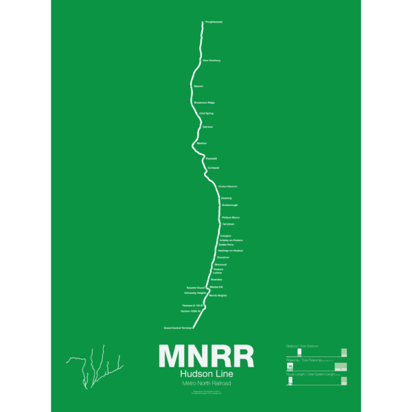
The Metro North Hudson Line runs from Grand Central Terminal to Poughkeepsie along the Hudson River and also serves Amtrak lines to Chicago, Vermont, and Montreal. The Hudson Line was chartered in 1846 to connect Troy, NY with Manhattan and by 1851 the line had been completed to Chambers St. Cornelius Vanderbilt bought the line in 1864 and merged it with the Harlem Line to create the New York Central. The line eventually stretched all the way to Chicago and served both commuter and intercity travelers.
After World War II ridership declined and the New York Central merged with the Pennsylvania Railroad but it still couldn’t compete. The Hudson Line became part of the Conrail network and commuter service was cut back to Poughkeepsie. In 1983 Metro North took over all operations of the line and invested in new tracks, stations and trains.
Printed on Satin finish 80# cover stock – 220 GSM. Made in the USA! Standard production time is 5 days. Allow more time for shipping.
Select options This product has multiple variants. The options may be chosen on the product page -
 Price range: $30.00 through $80.00
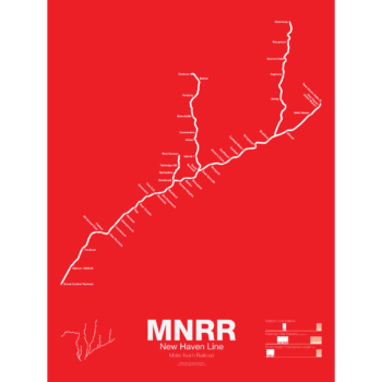
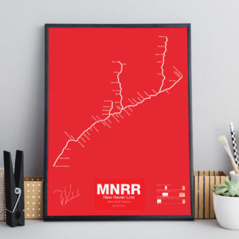
The Metro North New Haven Line runs from Grand Central Terminal to New Haven, CT with branches to New Canaan, Danbury, and Waterbury. Most of the Main Line runs along Amtrak’s Northeast Corridor, is owned by Connecticut DOT and is leased to Metro North for operations. The line started in 1849 connecting New York and New Haven. In 1872 the line was merged into J. P. Morgan’s giant New York, New Haven, and Hartford Railroad which was the largest railroad in New England at the time.
Today the New Haven Line ranks as the busiest rail line in the United States.
Printed on Satin finish 80# cover stock – 220 GSM. Made in the USA! Standard production time is 5 days. Allow more time for shipping.
Select options This product has multiple variants. The options may be chosen on the product page -
 Price range: $30.00 through $80.00
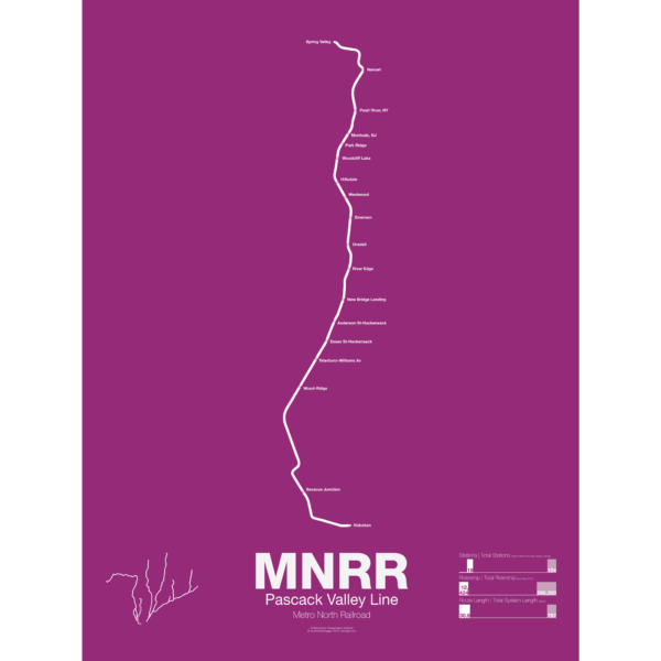
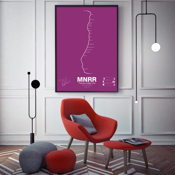
The Metro North Pascack Valley Line is a mostly single tracked line running from Spring Valley, NY through northern New Jersey to Hoboken Terminal. Pascack Valley is one of two Metro North lines which run through New Jersey (the other being the Port Jervis Line) but unlike the Port Jervis Line which is owned by Metro North in New York, the Pascack Valley Line is entirely owned by New Jersey Transit and the stations in New York are leased to Metro North. The line was originally chartered in 1856 and was bought by the Erie Railroad in 1896. New Jersey Transit and Metro North took over in 1983.
Printed on Satin finish 80# cover stock – 220 GSM. Made in the USA! Standard production time is 5 days. Allow more time for shipping.
Select options This product has multiple variants. The options may be chosen on the product page -

 Price range: $30.00 through $80.00
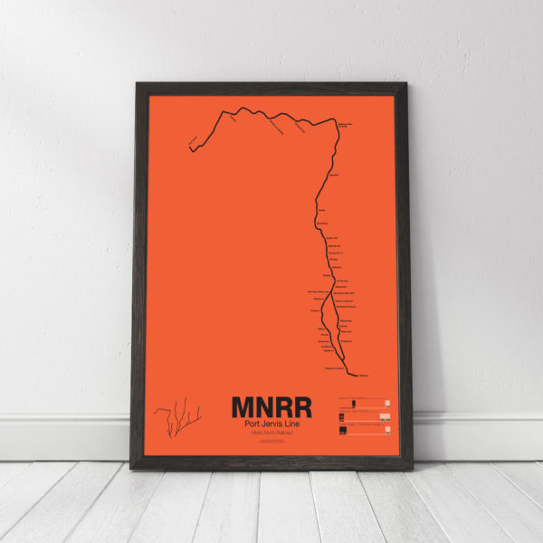
The Metro North Port Jervis Line runs from Port Jervis where Pennsylvania, New Jersey and New York meet, through Sullivan and Rockland Counties, NY, and then through northern New Jersey to the Hoboken Terminal in Hoboken, NJ. Much of the Port Jervis Line started as the New York and Erie Railroad Main Line, opening to Port Jervis in 1848. The original line ran through the towns of Monroe, Chester, Goshen, and Middletown but this stretch was abandoned in 1984 when Metro North chose to move service to a longer, but faster and straighter, route.
The Erie Main Line once reached Buffalo and Chicago via the Southern Tier of New York State but lost money and ridership after World War II. The Port Jervis Line is one of two Metro North lines which run through New Jersey. The tracks in New York are owned and operated by Metro North but the tracks in New Jersey are owned and operated by New Jersey Transit. Port Jervis trains run to Hoboken Terminal but transfers are available at Secaucus Junction for service to Penn Station.
Printed on Satin finish 80# cover stock – 220 GSM. Made in the USA! Standard production time is 5 days. Allow more time for shipping.
Select options This product has multiple variants. The options may be chosen on the product page -
 Price range: $390.00 through $515.00
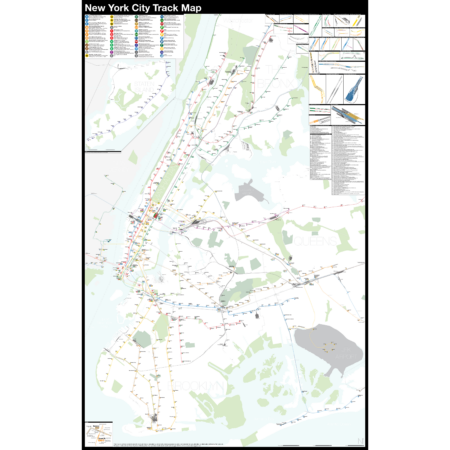
The Complete and Geographically Accurate New York City Track Map is a new, detailed look at the entire rail network that most riders never see. Unlike a traditional subway map which just shows train routes, stations, and a simplified geography for easier navigation, the Track Map shows how the system actually looks; each track, each switch, each station platform and each train yard is shown in a clear and clean design. While the Track Map offers a service guide, it is not intended to replace the subway map as a wayfinding tool. The Track Map shows the paths of the tracks so that the viewer can see how trains are able to run. If you’ve ever wondered why certain trains don’t run to certain places, this map will tell you why.
The idea behind this was to remove all distortion from traditional subway maps and see the system down to its bones. Street labels, parks, cemeteries, and airports help act as landmarks. The more complicated interchanges and interlockings are shown in a blown up detail section, along with a list of as many provisions and abandoned sections of the system I have discovered.
Fine art prints are made in Williamsburg, Brooklyn, NY on Semi-Gloss, 10mil Premium Luster Paper.
For more information about the map, see the original blog post here.
Select options This product has multiple variants. The options may be chosen on the product page