New York MTA
-
 Price range: $30.00 through $80.00
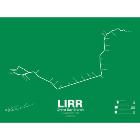
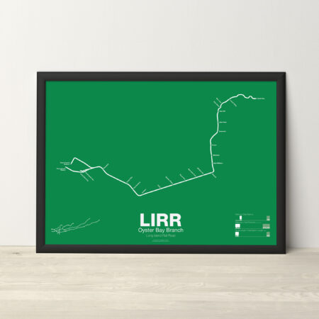
The LIRR Oyster Bay Branch opened in 1865 by the LIRR owned Glen Cove Branch RR as a branch off the Main Line at Mineola to Glen Head. The line was extended further and by 1867 it reached Locust Valley. An extension to Oyster Bay was only proposed as a counter to a rival railroad which had proposed a line to Northport. The LIRR eventually opened an extension to Oyster Bay in 1889. A large new pier was built next to the terminal for ferry service to New England. Although the line was intended to be electrified in the 1930s the work was never done and as such the line uses diesel trains which don’t run to Penn Station.
Printed on Satin finish 80# cover stock – 220 GSM. Made in the USA! Standard production time is 5 days. Allow more time for shipping.
Select options This product has multiple variants. The options may be chosen on the product page -
 Price range: $30.00 through $80.00
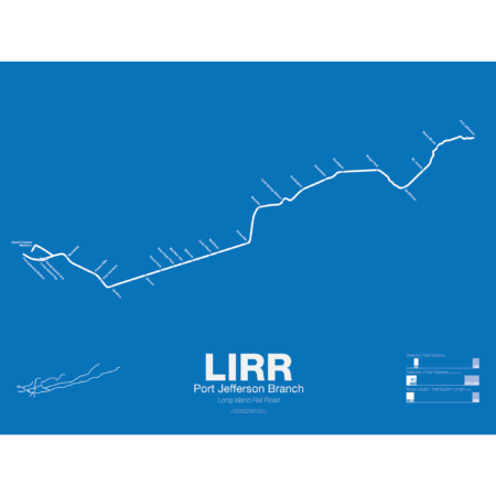
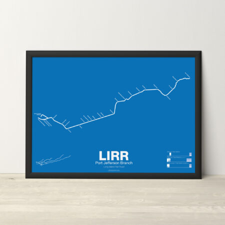
The LIRR Port Jefferson Branch is a branch off the Main Line at Hicksville and was opened to Syosset in 1854. The line was extended to Northport in 1868 but due to disputes between the LIRR and the towns of Cold Spring and Huntington the new line bypassed both. In 1873 the line was extended to Port Jefferson but branched off south of Northport, leaving the original terminal a spur line that would be abandoned by 1899. In 1895 the line was extended a final time to Wading River with plans on continuing it to Riverhead, though this was never done. The Wading River extension was eventually abandoned in 1938. Due to rising ridership the LIRR is constructing a third track along the Main Line from Floral Park to Hicksville so many Port Jefferson and Ronkonkoma trains can run express to Jamaica.
Printed on Satin finish 80# cover stock – 220 GSM. Made in the USA! Standard production time is 5 days. Allow more time for shipping.
Select options This product has multiple variants. The options may be chosen on the product page -
 Price range: $30.00 through $80.00
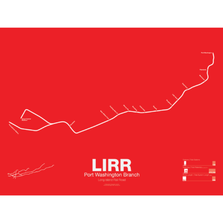
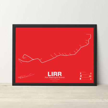
The LIRR Port Washington Branch runs from Penn Station to Port Washington through Flushing and is the only LIRR branch that does not run through Jamaica. Built and opened by the Flushing RR in 1854 it was the first non-LIRR railroad on Long Island. Originally the line was supposed to reach Roslyn, Oyster Bay and Huntington but this was thwarted by the LIRR which reached there first. By 1874 the Flushing RR had combined with other competitors to form the Flushing, North Shore and Central Railroad but in two years would be bought by the LIRR. Additionally there was a branch to Whitestone but this was eliminated in 1932.
Printed on Satin finish 80# cover stock – 220 GSM. Made in the USA! Standard production time is 5 days. Allow more time for shipping.
Select options This product has multiple variants. The options may be chosen on the product page -
 Price range: $30.00 through $80.00
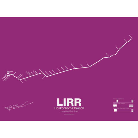
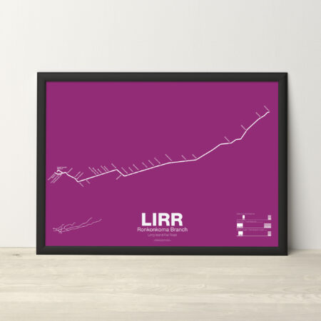
The LIRR Ronkonkoma Branch is the service which runs along most of the original Main Line of the LIRR from Brooklyn to Greenport through Hicksville. Service today runs to Ronkonkoma with shuttle service continuing to Greenport. The original Main Line opened from Brooklyn to Jamaica in 1836 and was extended to Hempstead in 1839. By 1844 the line had been extended out to Greenport with ferry service to New England. At the time train technology was thought too primitive to navigate the rough terrain of the Connecticut coast so a train-ferry-train service was devised to travel between New York and Boston. The LIRR Main Line ran as straight as possible down the center of Long Island, avoiding existing towns, to have the fastest service. But in 1848 a railroad was opened through Connecticut and the LIRR was now a railroad to nowhere. Over the next 30 years the LIRR grew by buying up the competition and by 1880 had a monopoly on Long Island. Today the LIRR is the oldest railroad in the country which still operates from its original charter.
Printed on Satin finish 80# cover stock – 220 GSM. Made in the USA! Standard production time is 5 days. Allow more time for shipping.
Select options This product has multiple variants. The options may be chosen on the product page -
 Price range: $30.00 through $80.00
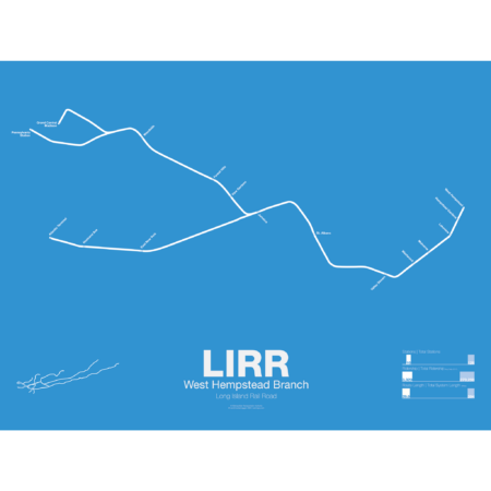
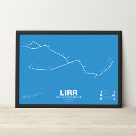
The LIRR West Hempstead Branch is a short, single track line which runs from Valley Stream to West Hempstead. Most service is run as a shuttle but a few trains are through run at peak times. The West Hempstead Branch was opened by the New York Bay Extension RR Company as part of a larger, unrealized line from Brooklyn to Garden City. The line originally had complex connections to the Hempstead Branch, Main Line, and Oyster Bay Branch so that many different services could be run. Eventually these connections were eliminated due to the need for grade separation.
Printed on Satin finish 80# cover stock – 220 GSM. Made in the USA! Standard production time is 5 days. Allow more time for shipping.
Select options This product has multiple variants. The options may be chosen on the product page -
 Price range: $30.00 through $80.00
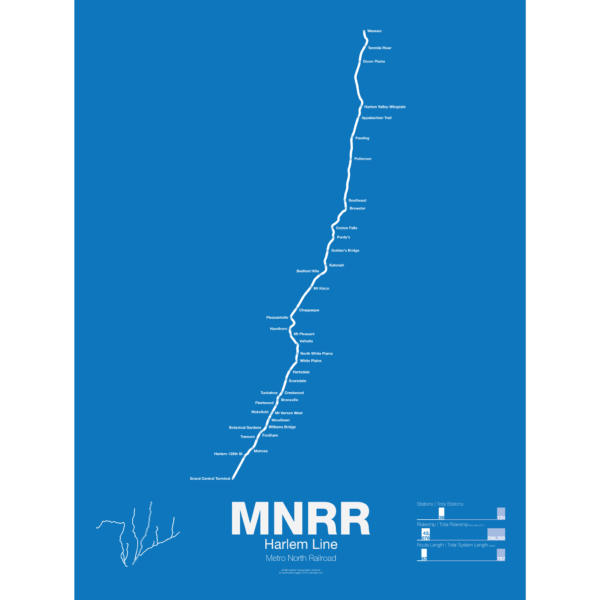
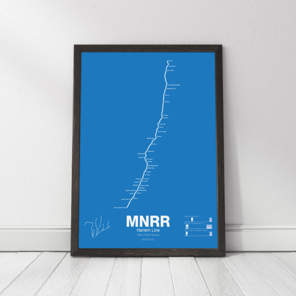
The Metro North Harlem Line runs from Grand Central Terminal in Manhattan to Wassic in Dutchess County, running through the posh suburbs in Westchester. The railroad began as a horse drawn streetcar line from lower Manhattan to the distant suburb (at the time) of Harlem in 1831. The line quickly grew with ambitions to reach Albany and beyond but only got to Chatham, NY in 1852 where riders could transfer to other trains to Boston, Albany, and to points north and west. Originally trains would end at 26th St and Park Ave in Manhattan but in 1871 the new Grand Central Depot was opened at 42nd St, at the time far from the heart of the city.
The Harlem Line was leased to the mighty New York Central Railroad in 1873 and would be a major part of their system until after World War II when the NYC and Pennsylvania Railroad merged. This couldn’t stop the losses and by 1971 a deal was stuck to lease the railroad to the Metropolitan Transportation Authority and was merged into the new Metro North Railroad. Service between Chatham and Dover Plains was ended and the MTA began to invest in new stations and modern equipment. In 2000 Metro North completed a reactivation of track from Dover Plains to Wassaic.
Printed on Satin finish 80# cover stock – 220 GSM. Made in the USA! Standard production time is 5 days. Allow more time for shipping.
Select options This product has multiple variants. The options may be chosen on the product page -
 Price range: $30.00 through $80.00
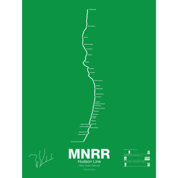
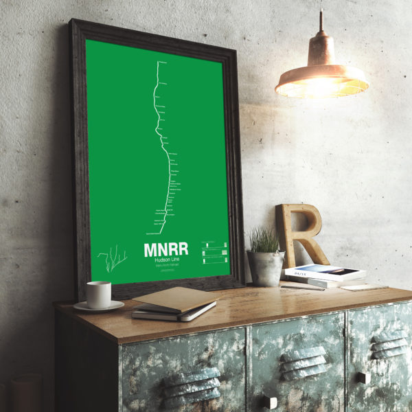
The Metro North Hudson Line runs from Grand Central Terminal to Poughkeepsie along the Hudson River and also serves Amtrak lines to Chicago, Vermont, and Montreal. The Hudson Line was chartered in 1846 to connect Troy, NY with Manhattan and by 1851 the line had been completed to Chambers St. Cornelius Vanderbilt bought the line in 1864 and merged it with the Harlem Line to create the New York Central. The line eventually stretched all the way to Chicago and served both commuter and intercity travelers.
After World War II ridership declined and the New York Central merged with the Pennsylvania Railroad but it still couldn’t compete. The Hudson Line became part of the Conrail network and commuter service was cut back to Poughkeepsie. In 1983 Metro North took over all operations of the line and invested in new tracks, stations and trains.
Printed on Satin finish 80# cover stock – 220 GSM. Made in the USA! Standard production time is 5 days. Allow more time for shipping.
Select options This product has multiple variants. The options may be chosen on the product page -
 Price range: $30.00 through $80.00
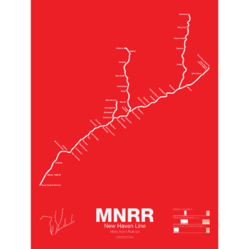
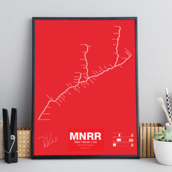
The Metro North New Haven Line runs from Grand Central Terminal to New Haven, CT with branches to New Canaan, Danbury, and Waterbury. Most of the Main Line runs along Amtrak’s Northeast Corridor, is owned by Connecticut DOT and is leased to Metro North for operations. The line started in 1849 connecting New York and New Haven. In 1872 the line was merged into J. P. Morgan’s giant New York, New Haven, and Hartford Railroad which was the largest railroad in New England at the time.
Today the New Haven Line ranks as the busiest rail line in the United States.
Printed on Satin finish 80# cover stock – 220 GSM. Made in the USA! Standard production time is 5 days. Allow more time for shipping.
Select options This product has multiple variants. The options may be chosen on the product page -
 Price range: $30.00 through $80.00
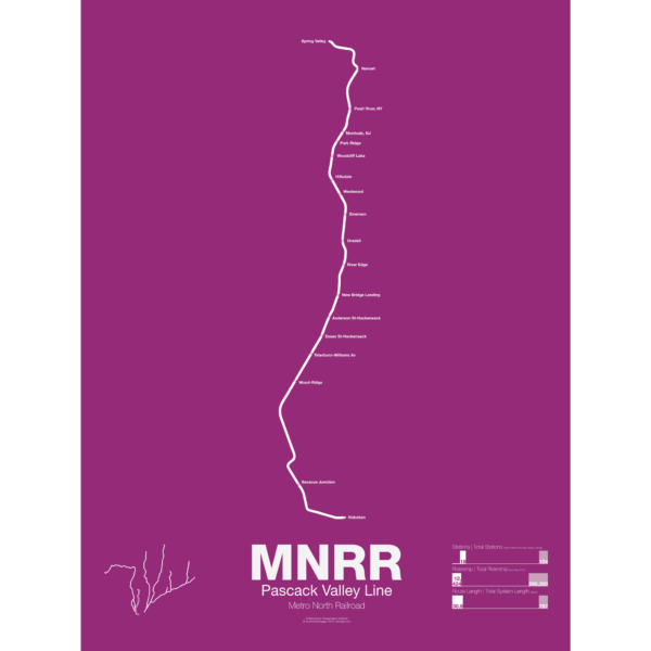
The Metro North Pascack Valley Line is a mostly single tracked line running from Spring Valley, NY through northern New Jersey to Hoboken Terminal. Pascack Valley is one of two Metro North lines which run through New Jersey (the other being the Port Jervis Line) but unlike the Port Jervis Line which is owned by Metro North in New York, the Pascack Valley Line is entirely owned by New Jersey Transit and the stations in New York are leased to Metro North. The line was originally chartered in 1856 and was bought by the Erie Railroad in 1896. New Jersey Transit and Metro North took over in 1983.
Printed on Satin finish 80# cover stock – 220 GSM. Made in the USA! Standard production time is 5 days. Allow more time for shipping.
Select options This product has multiple variants. The options may be chosen on the product page -

 Price range: $30.00 through $80.00
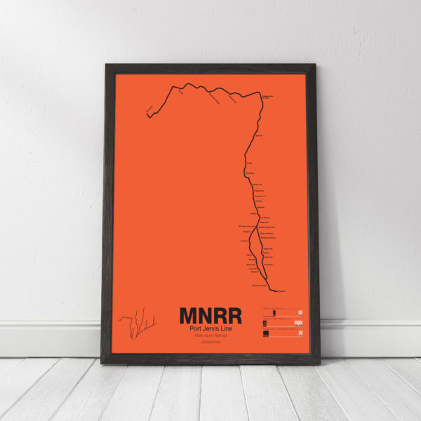
The Metro North Port Jervis Line runs from Port Jervis where Pennsylvania, New Jersey and New York meet, through Sullivan and Rockland Counties, NY, and then through northern New Jersey to the Hoboken Terminal in Hoboken, NJ. Much of the Port Jervis Line started as the New York and Erie Railroad Main Line, opening to Port Jervis in 1848. The original line ran through the towns of Monroe, Chester, Goshen, and Middletown but this stretch was abandoned in 1984 when Metro North chose to move service to a longer, but faster and straighter, route.
The Erie Main Line once reached Buffalo and Chicago via the Southern Tier of New York State but lost money and ridership after World War II. The Port Jervis Line is one of two Metro North lines which run through New Jersey. The tracks in New York are owned and operated by Metro North but the tracks in New Jersey are owned and operated by New Jersey Transit. Port Jervis trains run to Hoboken Terminal but transfers are available at Secaucus Junction for service to Penn Station.
Printed on Satin finish 80# cover stock – 220 GSM. Made in the USA! Standard production time is 5 days. Allow more time for shipping.
Select options This product has multiple variants. The options may be chosen on the product page -
 Price range: $25.00 through $80.00
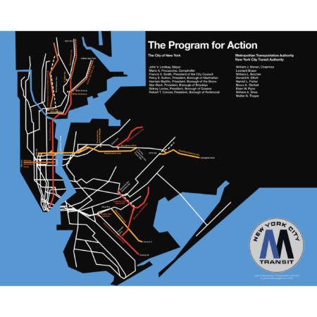
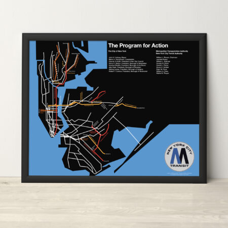
The Metropolitan Transportation Authority of New York was founded in 1968 with the mission of unifying all transit facilities under one roof. To reverse decades of under-investment of mass transit, the MTA released their ambitious Program for Action, a multiphase rehabilitation and expansion of the subways and commuter rail. At the core of the program was the 63rd St Tunnel and 2nd Ave Subway. Elevated lines in the Bronx, Queens, and Brooklyn would be replaced by subways, and existing lines would be extended deeper into the outer boroughs. The LIRR would be extended to Midtown East and Lower Manhattan, while electrification would be expanded on Long Island and the Hudson Valley.
The ambitions of the new agency immediately ran into the harsh reality of decades of disinvestment. The costs of simply fixing what existed proved vastly more expensive than originally thought. The City of New York had been over spending on services at the same time as the tax base dwindled. Within 6 years, most of these plans were quietly shelved. Work on the 2nd Ave Subway was halted (only to be restarted in 2007). Only the 63rd St Tunnel, which had advanced too far to cancel, and the Archer Ave Subway in Jamaica, which was being built with Federal funds, limped along. Both would only open in the late 1980s.
This print is a recreation of a promotion brochure from 1969. A more in depth history, with additional maps, can be found on my blog.
The map is printed at 16″x20″ on Satin finish 80# cover stock – 220 GSM. Made in the USA! Framed prints at the same size are also available. Standard production time is 5 Days. Please add more time for framing and shipping.
Select options This product has multiple variants. The options may be chosen on the product page -
 Price range: $390.00 through $515.00
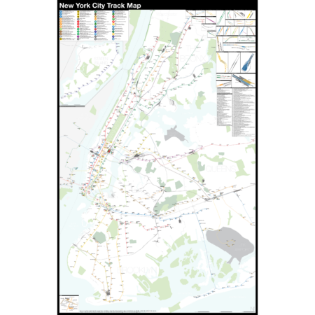
The Complete and Geographically Accurate New York City Track Map is a new, detailed look at the entire rail network that most riders never see. Unlike a traditional subway map which just shows train routes, stations, and a simplified geography for easier navigation, the Track Map shows how the system actually looks; each track, each switch, each station platform and each train yard is shown in a clear and clean design. While the Track Map offers a service guide, it is not intended to replace the subway map as a wayfinding tool. The Track Map shows the paths of the tracks so that the viewer can see how trains are able to run. If you’ve ever wondered why certain trains don’t run to certain places, this map will tell you why.
The idea behind this was to remove all distortion from traditional subway maps and see the system down to its bones. Street labels, parks, cemeteries, and airports help act as landmarks. The more complicated interchanges and interlockings are shown in a blown up detail section, along with a list of as many provisions and abandoned sections of the system I have discovered.
Fine art prints are made in Williamsburg, Brooklyn, NY on Semi-Gloss, 10mil Premium Luster Paper.
For more information about the map, see the original blog post here.
Select options This product has multiple variants. The options may be chosen on the product page -
 Price range: $30.00 through $80.00
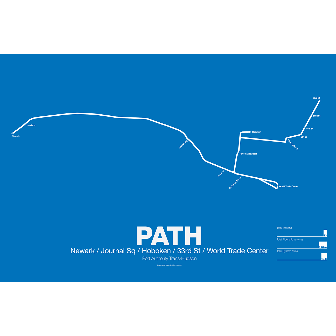
PATH (Port Authority Trans-Hudson), originally known as the Hudson and Manhattan Railroad (H&M), predates the original line of the NYC Subway. First planned in 1874, existing technologies could not safely tunnel under the Hudson River. Construction began on the existing tunnels in 1890, but stopped shortly thereafter when funding ran out. Construction did not resume until 1900 under the direction of William Gibbs McAdoo.
Opened in 1907, the Hudson and Manhattan Railroad tunnels were designed to link three of the major railroad terminals on the Hudson River in New Jersey—the Lackawanna in Hoboken, the Erie and PRR in Jersey City—with New York City. Two sets of tunnels connected commuters to the business centers in lower Manhattan and midtown Manhattan along 6th Ave. As the H&M was opened only 3 years after the original subway extensions were planned from 33rd St to Grand Central (original plans for Grand Central Terminal show space for a never built H&M station) and from 9th St to Astor Pl.
The H&M was only successful for a short 20 years as Pennsylvania Station opened in midtown in 1910 and the Holland Tunnel opened in 1927, diverting rail traffic from New Jersey terminals and then by commuters who chose to drive. Two original stations at 19th St and 28th St were closed to speed up service. By the 1950s the railroad was in bankruptcy but continued to operate. In 1961 the Port Authority was tapped to construct a new World Trade Center in lower Manhattan. In a deal with the states of New York and New Jersey the Port Authority agreed to take over the railroad and moved the location of the new WTC to the Hudson Terminal of the H&M in lower Manhattan. The Port Authority upgraded the system and changed the name to PATH.
Printed on Satin finish 80# cover stock – 220 GSM. Made in the USA! Standard production time is 5 Days. Please add more time for shipping.
Select options This product has multiple variants. The options may be chosen on the product page -
 Price range: $30.00 through $80.00
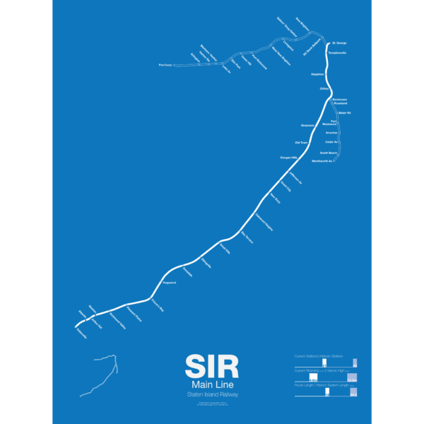
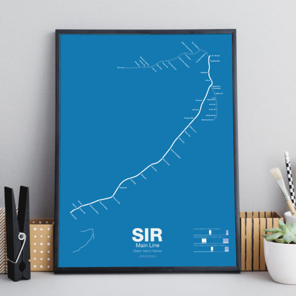
The Staten Island Railway was founded in 1851 as a way to connect the island to Cornelius Vanderbilt’s ferry to Manhattan. It was expanded in the 1880s with a North Shore Branch which connected the island to New Jersey and a South Beach Branch which ran past Fort Wadsworth to the beaches on the islands southeastern shore. The railroad served both passenger and freight traffic. In the 1920s the railroad was electrified in anticipation of a connection to the subway in Brooklyn but the tunnel was never built. After World War II ridership dropped as more residents chose to drive or take cheaper buses over the new bridges to New Jersey. Service on the North Shore and South Beach Branches was ended in 1953, though the North Shore Branch was (and still partially is) still used for freight. Plans have been floated to reactive the North Shore Branch as rail or bus rapid transit but so far nothing has been done.
This poster shows the existing Main Line and two former branches, the North Shore Branch to Port Ivory and the South Beach Branch to Wentworth Ave.
Printed on Satin finish 80# cover stock – 220 GSM. Made in the USA! Standard production time is 5 days. Allow more time for shipping.
Select options This product has multiple variants. The options may be chosen on the product page -
 Price range: $30.00 through $80.00
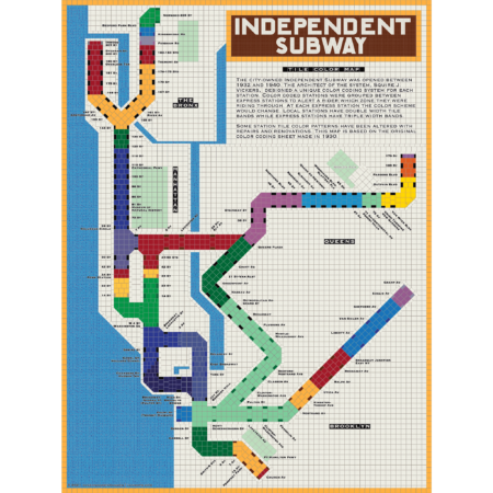
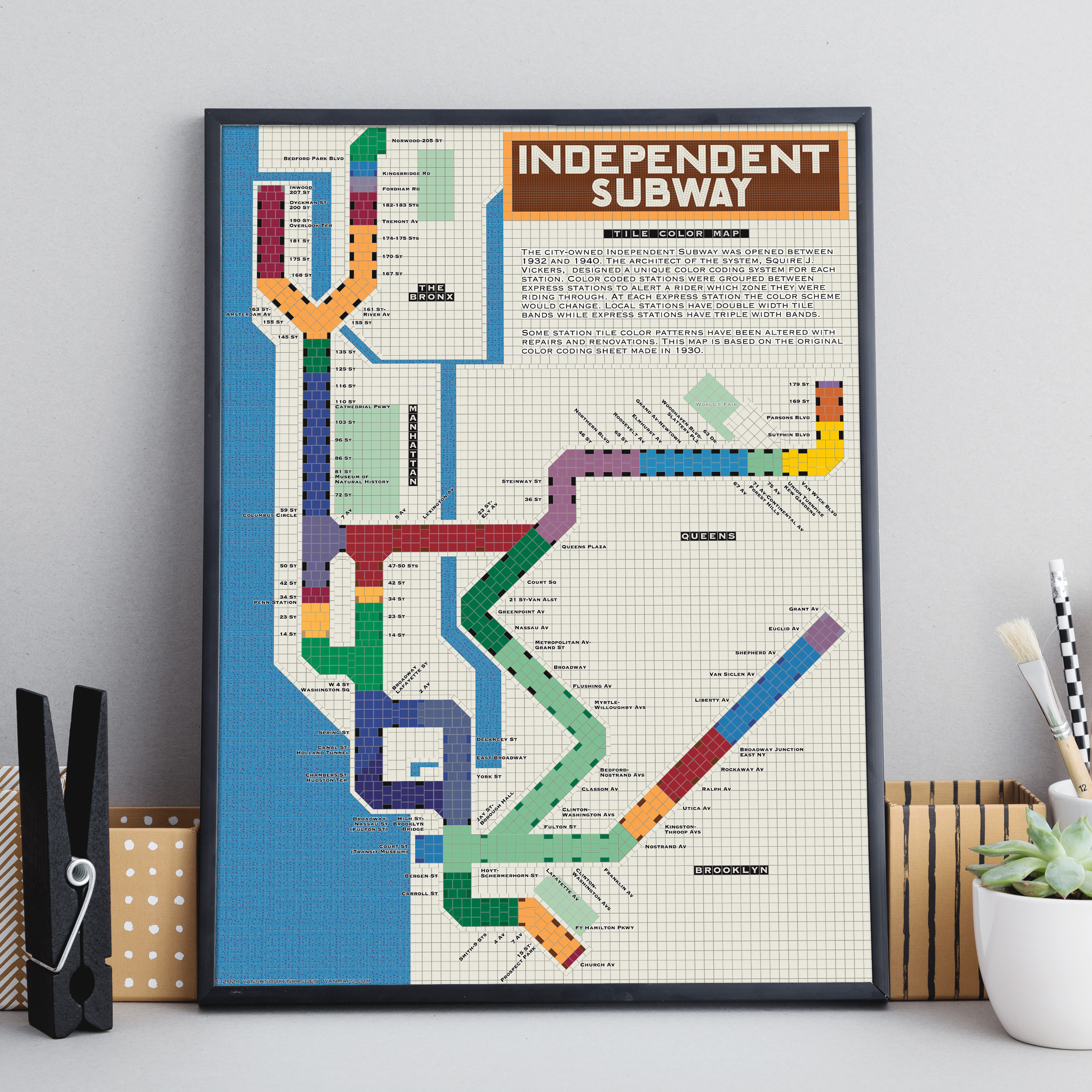
The City of New York built Independent Subway (A/B/C/D/E/F/G trains) was opened between 1932 and 1940. All the subway stations at the time featured tile bands and art unique to each station. The IND’s architect, Squire Vickers, created a new tile pattern based on color theory. He grouped express and local stations with color so that each time a rider rode through an express station the color of the tiles would change. He created a modern, streamlined design which featured two colors per station. The idea was that a rider would recognize their station’s color and know when to get off. This map shows how each color group looks when laid out like a subway map.
Note: The design features an orange tile outline. Some frames may obscure this outline.
Printed on Satin finish 80# cover stock – 220 GSM, 18″ x 24″.
Select options This product has multiple variants. The options may be chosen on the product page